Get the Latest in Your Inbox
Want to stay up to date on the state of the world’s forests? Subscribe to our mailing list.
Subscribe
This is an archive of the Forest Pulse, which is updated annually using annual tree cover loss data to provide a comprehensive overview on where forests have been lost around the world. Annual updates are released each year and cover the previous year’s trends. View the latest analysis here.
Primary Rainforest Destruction Increased 12% from 2019 to 2020
By Mikaela Weisse and Liz Goldman
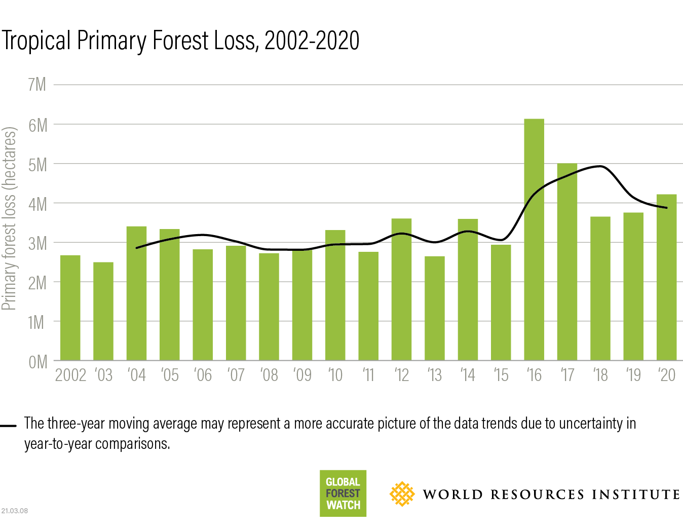
The tropics lost 12.2 million hectares of tree cover in 2020, according to new data from the University of Maryland and available on Global Forest Watch.
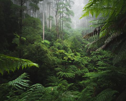
Of that, 4.2 million hectares, an area the size of the Netherlands, occurred within humid tropical primary forests, which are especially important for carbon storage and biodiversity. The resulting carbon emissions from this primary forest loss (2.64 Gt CO2) are equivalent to the annual emissions of 570 million cars, more than double the number of cars on the road in the United States.
Primary forest loss was 12% higher in 2020 than the year before, and it was the second year in a row that primary forest loss worsened in the tropics.
More
2020 was meant to be a landmark year in the fight against deforestation – a year by which many companies, countries and international organizations had pledged to halve or completely stop forest loss. Continued losses of primary tropical forests make it clear that humanity has fallen short in meeting these targets.
More
As in past years, commodity-driven deforestation was the leading cause of tree cover loss (both in primary and secondary forests) in Latin America and Southeast Asia, while shifting agriculture dominates in tropical Africa. In addition, fires and other climate-related impacts continued to play a big role, both in the tropics and beyond.
More
How Did COVID-19 Affect the World’s Forests?
The data does not reveal any obvious, systematic shift in forest loss trends that can be clearly linked to COVID-19. Nonetheless, the coronavirus pandemic and associated lockdowns have reshaped the world in many ways that are likely to impact forests.
Most directly, there have been reports of increased illegal harvesting in protected areas, many of which were temporarily closed to the public and had restrictions on ranger activities. It remains to be seen how other pandemic-related trends — like large numbers of people returning to rural areas, or disruptions to supply chains — will affect forests.
Perhaps even more important than the immediate impact of lockdowns and travel restrictions is how countries choose to rebuild their economies after the coronavirus pandemic. Some countries have already weakened environmental protections in the name of economic recovery. Whether countries take the opportunity to rebuild in a way that better safeguards their forests, or instead resort to cutting them down to bring back their economies, will impact forest loss for years to come.
More
Here’s a deeper look at some of the trends in forest loss in 2020:
More
Bright spots of hope for forests in Indonesia and Malaysia
While global deforestation numbers are distressing, progress in Southeast Asia offers a bright spot.
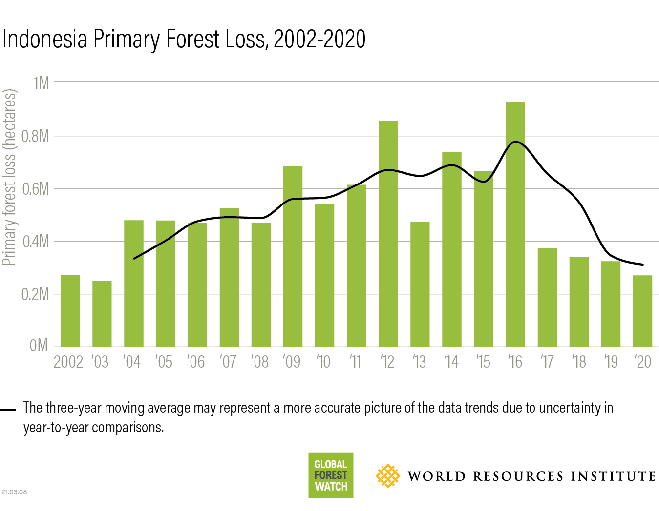
Indonesia’s rate of primary forest loss decreased for the fourth year in a row in 2020, one of only a few countries to do so. Indonesia also dropped out of the top three countries for primary forest loss for the first time since our record-keeping began.
More
A number of national and subnational initiatives appear to be having a long-term effect on reducing primary forest loss. After devastating forest and peat fires in 2015, Indonesia’s Ministry of Environment and Forestry stepped up its fire monitoring and prevention efforts. The government issued a temporary moratorium on new oil palm plantation licenses and a permanent moratorium on primary forest and peatlands conversion.
Agrarian and social forestry reforms have eased pressures on forests by alleviating poverty and encouraging sustainable land use. The mandate of the Peat Restoration Agency, responsible for protecting and restoring carbon-rich peatlands, was extended in 2020 and now includes mangrove forests, an important ecosystem for biodiversity and reducing the impact of extreme weather. Many subnational governments also recently made sustainable land use pledges backed by regulations that could curb deforestation going forward.
Primary forest loss also declined in Malaysia for the fourth year in a row. While this recent trend is good news, Malaysia has lost nearly a fifth of its primary forest since the year 2001; up to a third since the 1970s. The more recent downward trend and government actions are promising for conservation of remaining forests. Malaysia established a five-year cap on plantation area in 2019 and plans to toughen forest laws by increasing fines and jail terms for illegal logging.
In addition to government initiatives to curb primary forest loss in Indonesia and Malaysia, corporate commitments in the pulp and paper and oil palm sectors may also be reducing deforestation. No Deforestation, No Peat and No Exploitation (NDPE) Commitments now cover over 80% of the pulp and paper industry in Indonesia and 83% of palm oil refining capacity in Indonesia and Malaysia. The Roundtable on Sustainable Palm Oil tightened sustainable certification requirements in 2018 to include a ban on any deforestation or peatland clearing.
More
Building on Indonesia’s and Malaysia’s progress
While there is reason to celebrate this decline in primary forest loss, Indonesia and Malaysia must do more to strengthen existing policies to ensure this trend continues, including extending the oil palm plantation license moratorium which is set to expire in 2021. Regional climate and market conditions also may have reduced pressure on forests — conditions that could shift and, without the right measures in place, undo progress.
More
How Does Global Forest Watch Loss Data Compare to Official Estimates from Indonesia?
Official data from the Ministry of Environment and Forestry (MoEF) shows 119,000 hectares of annual gross forest loss from June 2019-July 2020, and a 75% decrease from their 2018/2019 to 2019/2020 reporting period. While the difference appears large compared to the 270,000 hectares and 17% decrease between 2019-2020 reported in the University of Maryland (UMD) data, it can be explained by methodological and definitional differences between the two datasets.
MoEF uses a minimum area requirement of 6.25 hectares, a July to June reporting period, and visual interpretation of satellite images to determine whether there was deforestation. The UMD data includes all loss greater than 0.1 hectares; removing areas under 6.25 ha in the 2020 UMD data brings the total loss to 123,000 hectares, much closer to MoEF’s estimate. The UMD data also uses a calendar year, which means the data includes the second half of 2020, a drier period that had some late-year loss spikes.
Finally, the difference in percent decline can be explained in part by definitional differences. MoEF statistics include loss in natural and plantation forests, while UMD includes only primary forests, the equivalent of MoEF’s natural forest area. The majority of the MoEF decline was in plantation areas. Using only natural forests, MoEF data shows a 38% decline, much closer to the 17% decline in the UMD data.
More
Wet weather in 2020 helped prevent the spread of fires that can burn out of control in dry weather years. Crude palm oil prices, which are correlated to Indonesia’s spikes in forest loss in 2009 and 2012, are back up to 2012 levels after a slump. Fire-monitoring efforts and NDPE commitments will play an important role in preventing future upticks in primary forest loss when climate and market conditions shift.
Coronavirus pandemic relief measures could also negatively impact forests in Indonesia. In the wake of COVID-19, Indonesia accelerated and passed the Omnibus Law to spur job creation and economic growth, which could jeopardize forests by relaxing environmental regulations. Indonesia also launched the food estate program to address potential food shortages related to the pandemic, which is exempt from the forest moratorium and puts peatland and protected forests in Central Kalimantan at risk through the establishment of new farmland for rice and other staple crops.
Unfortunately, the downward trend in primary forest loss in Indonesia and Malaysia is not visible in other Southeast Asian countries. Cambodia, Laosand Myanmar continue to see sustained or increasing levels of primary forest loss.
More
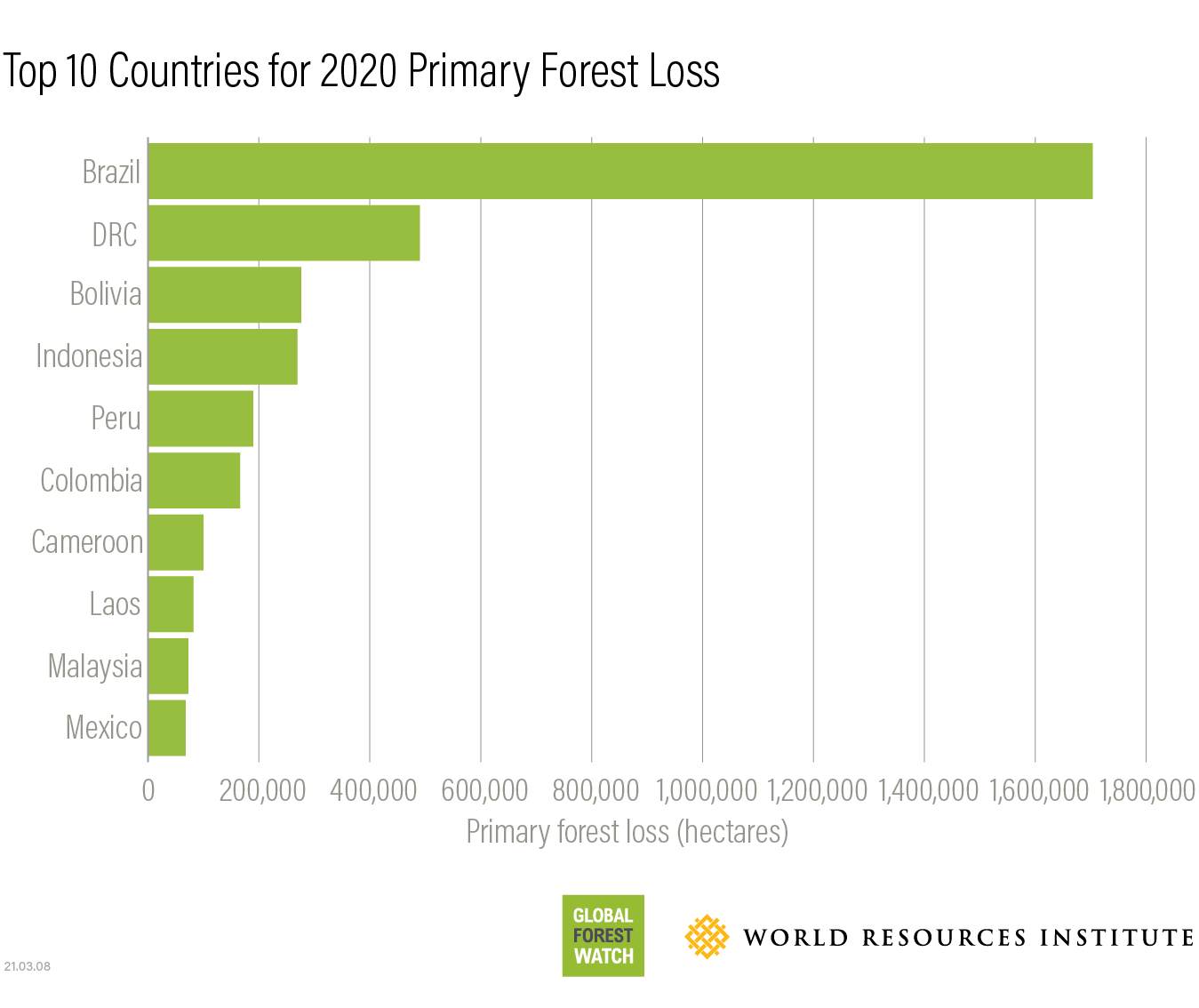
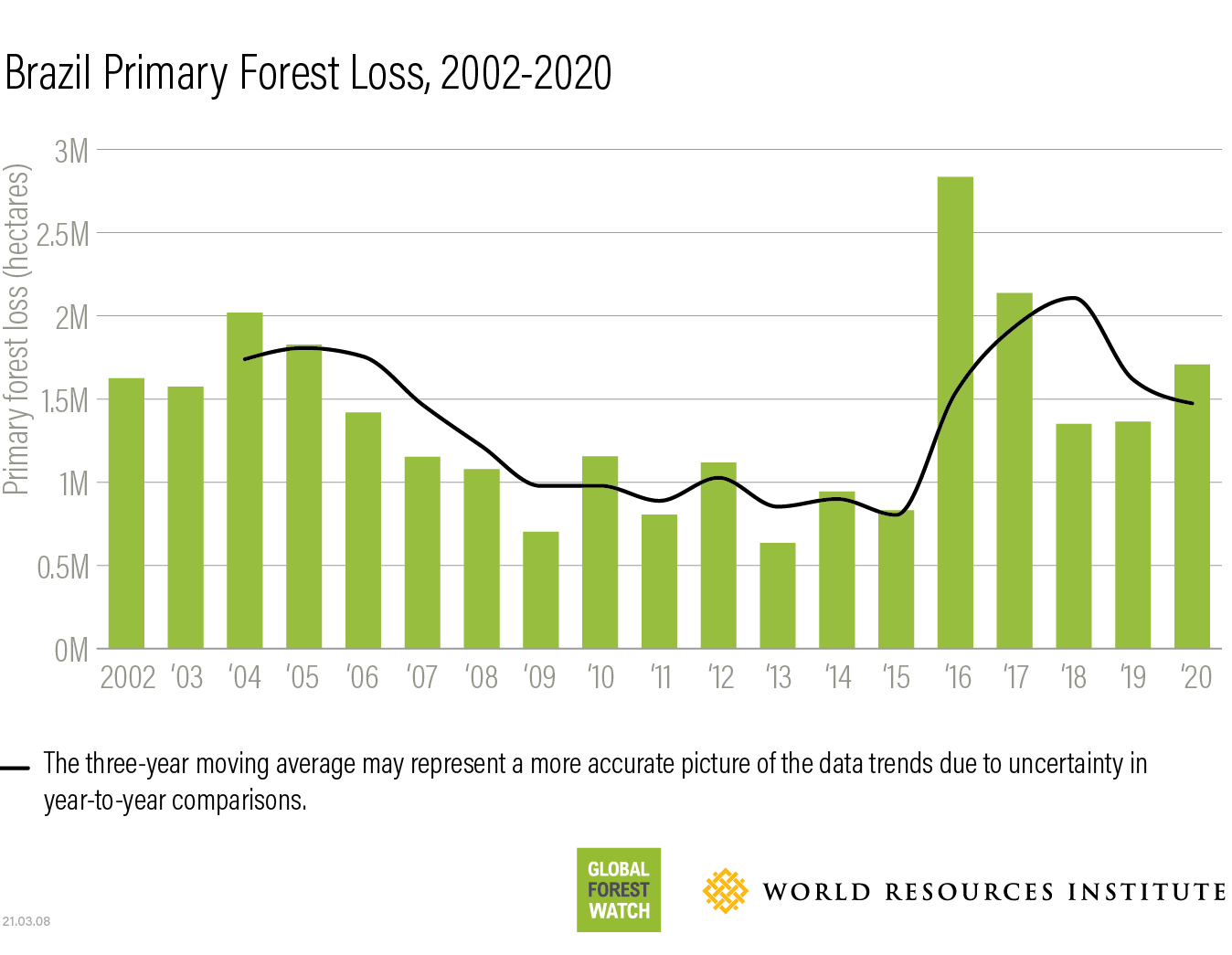
Brazil leads the world in primary forest loss, due to fires and clear-cutting
Brazil once more topped the list for annual primary forest loss with a total loss of 1.7 million hectares in 2020, more than three times the next-highest country. Primary forest loss in Brazil increased by 25% in 2020 compared to the year before.
More
The majority of humid primary forest loss in the country occurred in the Brazilian Amazon, which saw a 15% increase from last year, for a total of 1.5 million hectares. This matches the trend seen in government data, which specifically tracks large-scale clear-cuts in the Amazon (read more about the difference between these two data sources here). Newly cleared patches are particularly prevalent along the Amazon’s southern and eastern edges (known as the “arc of deforestation”) and along highways bisecting the Amazon rainforest, several of which are slated for expansion and paving in the coming years.
More
The data also shows a number of fire scars. The Brazilian Amazon had an even greater number of fires in 2020 than in 2019. This is concerning, as large fires rarely occur naturally in humid tropical forests like the Amazon.
In 2019, most fires occurred on already-deforested areas as farmers prepared land for agriculture and cattle pastures. In 2020, however, a significant share of the fires burned within forests as human-lit fires escaped beyond their intended extent due to dry conditions.
Greenhouse gas emissions from forest fires in the Amazon have at times outstripped those from clear-cut deforestation. Scientists fear that fires and associated emissions may increase in the future as climate change and further deforestation dry out forests and make them more vulnerable to fire. The resulting positive feedback loop could potentially transform the Amazoninto a savannah.
The high level of deforestation and fire activity in the Amazon happened despite a ban on fires during the peak of the season and military deploymentto curb illegal deforestation. That deployment is scheduled to end on April 30, 2021, with responsibility returning to federal enforcement agencies facing reduced budgets in 2021. The Amazon wasn’t the only biome in Brazil to experience an increase in humid primary forest loss in 2020, either. While only a small part of the country’s overall loss, the Pantanal, the world’s largest tropical wetland, experienced 16 times more primary forest loss in 2020 than the year before.
The spike is due to record-breaking fires. As in the Amazon, most of the 2020 fires in the Pantanal were started by people to manage land, but burned out of control in 2020 due to levels of drought not seen since the 1970s. Deforestation in other parts of South America may play a role in drying out the Pantanal, and climate change is likely to make extreme events happen more regularly.
Experts estimate that around 30% of the Pantanal burned in 2020, including several protected areas. Several indigenous territories burned, leaving tribes like the Guató without food or clean water. The fires also had a devastating impact on biodiversity, with thousands of animals killed or injured as a result of the blazes, including jaguars and other vulnerable species. While the long-term impact is unclear, the unprecedented nature of the fires means that some areas of the Pantanal likely won’t recover for decades.
More
Fires burning in the Pantanal wetlands in 2019. Fires continued in 2020, leading to a huge spike in forest loss in the Pantanal. Photo by Chico Ribiero/Governo Mato Grosso
More
Bolivia, Colombia and Peru see high levels of forest loss
Elsewhere in South America, forests have not fared much better.
Despite a slight drop in primary forest loss from the year before, Bolivia rose to number three on the list of countries with the most humid tropical primary forest loss in 2020, passing Indonesia for the first time. As in 2019, forest fires played a big role. Notably, the blazes affected several protected areas, including Noel Kempff Mercado National Park. As in Brazil, most of Bolivia’s fires were likely set by people to clear land, but raged out of control due to drought conditions and hot weather. Large-scale agriculture also affected forests, including numerous new clearings in the department of Santa Cruz.
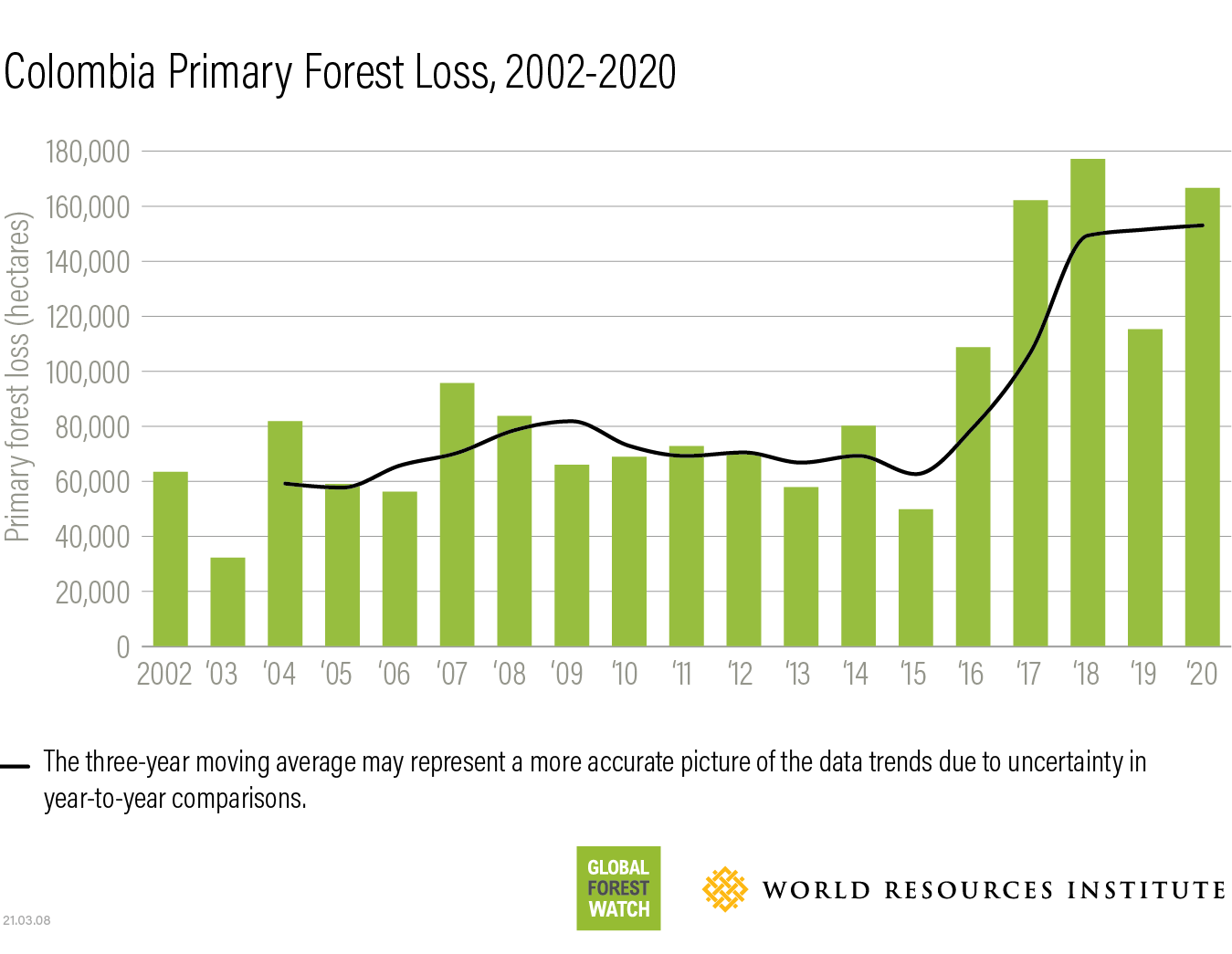
Meanwhile, in Colombia, the rate of primary forest loss rose in 2020 after a dip the previous year.
Colombia has sustained high rates of primary forest loss since the government’s 2016 peace agreement with the FARC, which led to a power vacuum in previously controlled forest areas. While the 2019 data offered a glimmer of hope that the country might have been curbing primary forest loss, the rate in 2020 was back up to levels seen in 2017 and 2018. Meanwhile, the government has publicly stepped up its ambition on deforestation, setting a goal of zero deforestation by 2030 as part of its commitment to reduce greenhouse gas emissions by 51% over the same period.
Deforestation continues to move deeper into the Colombian Amazon rainforest, as well as into several protected areas like Chiribiquete, Tinigua, and Sierra de la Macarena National Parks. Armed groups have taken control in several of the country’s protected areas. Staff were forced to leave 10 parks in February 2020 due to threats to their safety.
More
Peru, in fifth place for most tropical forest loss, also saw high and increasing rates of forest loss in 2020. Much of the loss appears to be smaller clearings, likely for agriculture and cattle ranching. The data also shows a number of new logging roads throughout the Peruvian Amazon rainforest in 2020. The country has historically faced high rates of illegal timber extraction. Gold mining has also previously been a major driver of deforestation in the southern part of the country, but seemingly slowed in 2019 and 2020 thanks to government interventions.
More
Agriculture drives forest loss in Congo Basin
Rates of primary forest loss in Gabon, the Republic of Congo, Central African Republic and Equatorial Guinea have all fluctuated in recent years, but loss increased dramatically in Cameroon, nearly doubling in 2020 compared to 2019. This increase was driven primarily by small-scale shifting agriculture in the southern part of the country.
While it is difficult to pinpoint what is driving this agricultural expansion, it could be related to urban-rural migration related to pandemic job losses and increases in commodity prices, especially cocoa and oil palm.
The Democratic Republic of the Congo (DRC) lost 490,000 hectares of primary forest in 2020, the second-highest amount of any country after Brazil. As in years past, the majority of forest loss continues to be caused by the expansion of small-scale shifting agriculture and wood energy demands, including charcoal production.
More must be done by the DRC government as well as all local, national and international stakeholders to understand the underlying drivers of this loss and build capacity for solutions. Future primary forest loss can be prevented through improvements to agriculture practices so that farmers can secure higher yields in areas already under cultivation rather than convert primary forests to farmland. The restoration of degraded areas, sustainable logging practices, regulation of wood energy and access to clean energy would also further decrease pressure on remaining forests.
More
What are the effects of climate change on forests?
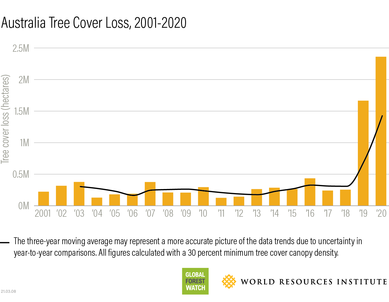
In addition to the mostly human-caused loss in the above countries, forests also faced a multitude of climate-related disturbances in 2020, both in humid primary tropical forests and other tree cover. Fires, fueled by regional droughts, have led to spikes in loss in places as diverse as the Brazilian Pantanal, Bolivia, Australia and Russia.
Meanwhile, storm and insect damage increased tree cover loss in Central America and Central Europe, respectively. These dynamics underscore the dual-sided relationship between forests and climate change – not only do forests affect the climate by absorbing carbon when growing and emitting it when cleared, they also can face direct impacts as a result of changing temperature and precipitation patterns.
In Australia, fires from late 2019 and early 2020 resulted in a nine-fold increase in tree cover loss in 2020 compared to 2018. Extreme weather was behind the spike, with climate change likely to make fire-prone conditions more common in the future.
More
Russia also saw high rates of tree cover loss in 2020, in large part due to fires in Siberia. Siberia experienced abnormally high temperatures in the spring and summer of 2020, likely due to climate change, which dried out forests and led to massive burning. Fires also burned within carbon-rich peatlandsthat are usually frozen, resulting in record carbon emissions that will exacerbate climate change.
In contrast, Canada had an unusually quiet fire year, resulting in a 45% decrease in tree cover loss compared to 2019. Experts cite a combination of factors to explain the lack of fires, including cooler, wetter weather and restrictions on fires and off-road vehicles during COVID-19 lockdowns.
Other natural factors were also at play in 2020. In Nicaragua, forests showed damage from Hurricanes Eta and Iota, which both made landfall in November 2020. The hurricanes were part of the Atlantic Ocean’s most active hurricane season on record, with climate change likely playing a role in the intensity of the storms and the longer-than-usual season.
Finally, Central Europe saw unprecedented levels of tree cover loss in 2020 and the year prior, with three-fold increases in Germany and Czech Republiccompared to 2018. The spike is in large part due to damage from bark beetles, which have caused particular damage to vulnerable trees as a result of hot and dry weather associated with climate change.
More
The future of forests will depend on the actions taken today
The new data makes it clear that we continue to lose forests at a staggering rate and that many forest-related targets with 2020 deadlines were missed.
The situation is increasingly urgent: the effects of climate change are already being felt, countless species are being lost to the extinction crisis, and forest clearing linked to land-grabbing is having irreversible impacts on the rights, livelihoods and cultural heritage of numerous forest peoples.
Indonesia and Malaysia provide reasons for optimism, but the situation in Brazil and elsewhere shows that high deforestation rates can return if forest protection efforts are not sustained. Initiatives to rebuild economies in the aftermath of the coronavirus pandemic offer an opportunity to reimagine policies and economies in a way that protects forests before it’s too late.
More
{"Glossary":{"51":{"name":"agricultural tree crops","description":"Trees cultivated for their food, cultural, or economic values. These include oil palm, rubber, cocoa, cashew, mango, oranges (citrus), plantain, banana, and coconut.\r\n"},"141":{"name":"agroforestry","description":"A diversified set of agricultural or agropastoral production systems that integrate trees in the agricultural landscape.\r\n"},"101":{"name":"albedo","description":"The ability of surfaces to reflect sunlight.\u0026nbsp;Light-colored surfaces return a large part of the sunrays back to the atmosphere (high albedo). Dark surfaces absorb the rays from the sun (low albedo).\r\n"},"94":{"name":"biodiversity intactness","description":"The proportion and abundance of a location\u0027s original forest community (number of species and individuals) that remain.\u0026nbsp;\r\n"},"95":{"name":"biodiversity significance","description":"The importance of an area for the persistence of forest-dependent species based on range rarity.\r\n"},"142":{"name":"boundary plantings","description":"Trees planted along boundaries or property lines to mark them well.\r\n"},"98":{"name":"carbon dioxide equivalent (CO2e)","description":"Carbon dioxide equivalent (CO2e) is a measure used to aggregate emissions from various greenhouse gases (GHGs) on the basis of their 100-year global warming potentials by equating non-CO2 GHGs to the equivalent amount of CO2.\r\n"},"99":{"name":"CO2e","description":"Carbon dioxide equivalent (CO2e) is a measure used to aggregate emissions from various greenhouse gases (GHGs) on the basis of their 100-year global warming potentials by equating non-CO2 GHGs to the equivalent amount of CO2.\r\n"},"1":{"name":"deforestation","description":"The change from forest to another land cover or land use, such as forest to plantation or forest to urban area.\r\n"},"77":{"name":"deforested","description":"The change from forest to another land cover or land use, such as forest to plantation or forest to urban area.\r\n"},"76":{"name":"degradation","description":"The reduction in a forest\u2019s ability to perform ecosystem services, such as carbon storage and water regulation, due to natural and anthropogenic changes.\r\n"},"75":{"name":"degraded","description":"The reduction in a forest\u2019s ability to perform ecosystem services, such as carbon storage and water regulation, due to natural and anthropogenic changes.\r\n"},"79":{"name":"disturbances","description":"A discrete event that changes the structure of a forest ecosystem.\r\n"},"68":{"name":"disturbed","description":"A discrete event that changes the structure of a forest ecosystem.\r\n"},"65":{"name":"driver of tree cover loss","description":"The direct cause of forest disturbance.\r\n"},"70":{"name":"drivers of loss","description":"The direct cause of forest disturbance.\r\n"},"81":{"name":"drivers of tree cover loss","description":"The direct cause of forest disturbance.\r\n"},"102":{"name":"evapotranspiration","description":"When solar energy hitting a forest converts liquid water into water vapor (carrying energy as latent heat) through evaporation and transpiration.\r\n"},"2":{"name":"forest","description":"Forests include tree cover greater than 30 percent tree canopy density and greater than 5 meters in height as mapped at a 30-meter Landsat pixel scale.\r\n"},"3":{"name":"forest concession","description":"A legal agreement allowing an entity the right to manage a public forest for production purposes.\r\n"},"90":{"name":"forest concessions","description":"A legal agreement allowing an entity the right to manage a public forest for production purposes.\r\n"},"53":{"name":"forest degradation","description":"The reduction in a forest\u2019s ability to perform ecosystem services, such as carbon storage and water regulation, due to natural and anthropogenic changes.\r\n"},"54":{"name":"forest disturbance","description":"A discrete event that changes the structure of a forest ecosystem.\r\n"},"100":{"name":"forest disturbances","description":"A discrete event that changes the structure of a forest ecosystem.\r\n"},"5":{"name":"forest fragmentation","description":"The breaking of large, contiguous forests into smaller pieces, with other land cover types interspersed.\r\n"},"6":{"name":"forest management plan","description":"A plan that documents the stewardship and use of forests and other wooded land to meet environmental, economic, social, and cultural objectives. Such plans are typically implemented by companies in forest concessions.\r\n"},"62":{"name":"forests","description":"Forests include tree cover greater than 30 percent tree canopy density and greater than 5 meters in height as mapped at a 30-meter Landsat pixel scale.\r\n"},"69":{"name":"fragmentation","description":"The breaking of large, contiguous forests into smaller pieces, with other land cover types interspersed.\r\n"},"80":{"name":"fragmented","description":"The breaking of large, contiguous forests into smaller pieces, with other land cover types interspersed.\r\n"},"74":{"name":"gain","description":"The establishment of tree canopy in an area that previously had no tree cover. Tree cover gain may indicate a number of potential activities, including natural forest growth or the crop rotation cycle of tree plantations.\r\n"},"143":{"name":"global land squeeze","description":"Pressure on finite land resources to produce food, feed and fuel for a growing human population while also sustaining biodiversity and providing ecosystem services.\r\n"},"7":{"name":"hectare","description":"One hectare equals 100 square meters, 2.47 acres, or 0.01 square kilometers and is about the size of a rugby field. A football pitch is slightly smaller than a hectare (pitches are between 0.62 and 0.82 hectares).\r\n"},"66":{"name":"hectares","description":"One hectare equals 100 square meters, 2.47 acres, or 0.01 square kilometers and is about the size of a rugby field. A football pitch is slightly smaller than a hectare (pitches are between 0.62 and 0.82 hectares).\r\n"},"67":{"name":"intact","description":"A forest that contains no signs of human activity or habitat fragmentation as determined by remote sensing images and is large enough to maintain all native biological biodiversity.\r\n"},"78":{"name":"intact forest","description":"A forest that contains no signs of human activity or habitat fragmentation as determined by remote sensing images and is large enough to maintain all native biological biodiversity.\r\n"},"8":{"name":"intact forests","description":"A forest that contains no signs of human activity or habitat fragmentation as determined by remote sensing images and is large enough to maintain all native biological biodiversity.\r\n"},"55":{"name":"land and environmental defenders","description":"People who peacefully promote and protect rights related to land and\/or the environment.\r\n"},"9":{"name":"loss driver","description":"The direct cause of forest disturbance.\r\n"},"10":{"name":"low tree canopy density","description":"Less than 30 percent tree canopy density.\r\n"},"84":{"name":"managed forest concession","description":"Areas where governments have given rights to private companies to harvest timber and other wood products from natural forests on public lands.\r\n"},"83":{"name":"managed forest concession maps for nine countries","description":"Cameroon, Canada, Central African Republic, Democratic Republic of the Congo, Equatorial Guinea, Gabon, Indonesia, Liberia, and the Republic of the Congo\r\n"},"104":{"name":"managed natural forests","description":"Naturally regenerated forests with signs of management, including logging, clear cuts, etc.\r\n"},"91":{"name":"megacities","description":"A city with more than 10 million people.\r\n"},"57":{"name":"megacity","description":"A city with more than 10 million people."},"56":{"name":"mosaic restoration","description":"Restoration that integrates trees into mixed-use landscapes, such as agricultural lands and settlements, where trees can support people through improved water quality, increased soil fertility, and other ecosystem services. This type of restoration is more likely in deforested or degraded forest landscapes with moderate population density (10\u2013100 people per square kilometer). "},"86":{"name":"natural","description":"A forest that is grown without human intervention.\r\n"},"12":{"name":"natural forest","description":"A forest that is grown without human intervention.\r\n"},"63":{"name":"natural forests","description":"A forest that is grown without human intervention.\r\n"},"144":{"name":"open canopy systems","description":"Individual tree crowns that do not overlap to form a continuous canopy layer.\r\n"},"82":{"name":"persistent gain","description":"Forests that have experienced one gain event from 2001 to 2016.\r\n"},"13":{"name":"persistent loss and gain","description":"Forests that have experienced one loss or one gain event from 2001 to 2016."},"97":{"name":"plantation","description":"An area in which trees have been planted, generally for commercial purposes.\u0026nbsp;\r\n"},"93":{"name":"plantations","description":"An area in which trees have been planted, generally for commercial purposes.\u0026nbsp;\r\n"},"88":{"name":"planted","description":"A forest composed of trees that have been deliberately planted and\/or seeded by humans.\r\n"},"14":{"name":"planted forest","description":"Stand of planted trees \u2014 other than tree crops \u2014 grown for wood and wood fiber production or for ecosystem protection against wind and\/or soil erosion.\r\n"},"73":{"name":"planted forests","description":"Stand of planted trees \u2014 other than tree crops \u2014 grown for wood and wood fiber production or for ecosystem protection against wind and\/or soil erosion."},"148":{"name":"planted trees","description":"Stand of trees established through planting, including both planted forest and tree crops."},"149":{"name":"Planted trees","description":"Stand of trees established through planting, including both planted forest and tree crops."},"15":{"name":"primary forest","description":"Old-growth forests that are typically high in carbon stock and rich in biodiversity. The GFR uses a humid tropical primary rainforest data set, representing forests in the humid tropics that have not been cleared in recent years.\r\n"},"64":{"name":"primary forests","description":"Old-growth forests that are typically high in carbon stock and rich in biodiversity. The GFR uses a humid tropical primary rainforest data set, representing forests in the humid tropics that have not been cleared in recent years.\r\n"},"58":{"name":"production forest","description":"A forest where the primary management objective is to produce timber, pulp, fuelwood, and\/or nonwood forest products."},"89":{"name":"production forests","description":"A forest where the primary management objective is to produce timber, pulp, fuelwood, and\/or nonwood forest products.\r\n"},"87":{"name":"seminatural","description":"A managed forest modified by humans, which can have a different species composition from surrounding natural forests.\r\n"},"59":{"name":"seminatural forests","description":"A managed forest modified by humans, which can have a different species composition from surrounding natural forests. "},"96":{"name":"shifting agriculture","description":"Temporary loss or permanent deforestation due to small- and medium-scale agriculture.\r\n"},"103":{"name":"surface roughness","description":"Surface roughness of forests creates\u0026nbsp;turbulence that slows near-surface winds and cools the land as it lifts heat from low-albedo leaves and moisture from evapotranspiration high into the atmosphere and slows otherwise-drying winds. \r\n"},"17":{"name":"tree cover","description":"All vegetation greater than five meters in height and may take the form of natural forests or plantations across a range of canopy densities. Unless otherwise specified, the GFR uses greater than 30 percent tree canopy density for calculations.\r\n"},"71":{"name":"tree cover canopy density is low","description":"Less than 30 percent tree canopy density.\r\n"},"60":{"name":"tree cover gain","description":"The establishment of tree canopy in an area that previously had no tree cover. Tree cover gain may indicate a number of potential activities, including natural forest growth or the crop rotation cycle of tree plantations.\u0026nbsp;As such, tree cover gain does not equate to restoration.\r\n"},"18":{"name":"tree cover loss","description":"The removal or mortality of tree cover, which can be due to a variety of factors, including mechanical harvesting, fire, disease, or storm damage. As such, loss does not equate to deforestation.\r\n"},"150":{"name":"tree crops","description":"Stand of perennial trees that produce agricultural products, such as rubber, oil palm, coffee, coconut, cocoa and orchards."},"19":{"name":"tree plantation","description":"An agricultural plantation of fast-growing tree species on short rotations for the production of timber, pulp, or fruit.\r\n"},"72":{"name":"tree plantations","description":"An agricultural plantation of fast-growing tree species on short rotations for the production of timber, pulp, or fruit.\r\n"},"85":{"name":"trees outside forests","description":"Trees found in urban areas, alongside roads, or within agricultural land\u0026nbsp;are often referred to as Trees Outside Forests (TOF).\u202f\r\n"},"151":{"name":"unmanaged","description":"Naturally regenerated forests without any signs of management, including primary forest."},"105":{"name":"unmanaged natural forests","description":"Naturally regenerated forests without any signs of management, including primary forest.\r\n"}}}