Get the Latest in Your Inbox
Want to stay up to date on the state of the world’s forests? Subscribe to our mailing list.
Subscribe
What is the condition of the world’s forests?
Forest condition considers the quality of standing forests, which can decline through forest degradation and fragmentation. Forest condition can vary because forests experience various degrees of degradation from human activities; for example, activities within forests such as selective logging and hunting often lead to degradation of standing forests. Additionally, when forests are fragmented by human activities such as farming or expansion of infrastructure like roads, more forest area is exposed as edges. This can lead to increased accessibility and exposure to threats such as the spread of fires from agricultural activities, selective logging, invasive species, and pollution, as well as changes to temperature, sun exposure, wind and humidity that can increase tree mortality. These edge effects, in addition to making remaining forest fragments more isolated from one another, can lead to loss of canopy height, carbon and biodiversity. Ecosystem integrity, defined by Grantham et al. (2020) as the degree to which an ecosystem is free from human modification of its structure, composition and function, can provide an important indication of the overall health of forests.
The Forest Landscape Integrity Index (FLII) estimates forest condition based on the degree of human modification by integrating data on observed and inferred human pressures and changes to forest connectivity into one composite index. The index characterizes integrity on a spectrum ranging from 0 (lowest integrity value) to 10 (highest integrity value), and index values can also be used to categorize forests more generally as having high, medium or low integrity. High integrity forests include areas of primary or naturally regenerated forests with little human impact, and are expected to be relatively more effective at performing key ecosystem functions than forests with lower integrity. On the other side of the spectrum, low integrity forests tend to be more heavily modified and may be fragmented, frequently disturbed or dominated by planted trees, indicating that they may be degraded.
As of 2019, 40.5 percent of forests globally had high integrity. Approximately a quarter had low integrity (25.6 percent), and the remaining 33.9 percent had medium integrity. The vast majority of the world’s high integrity forest can be found in boreal and tropical regions, including northern Russia, Canada and Alaska, as well as the Amazon, central Africa and New Guinea. Low integrity forests are widespread in Central and Western Europe, Southeastern United States, Southern Brazil, and parts of Central America and South and Southeast Asia.
More
Forest landscape integrity by climate domain
More
The global average Forest Landscape Integrity Index score is 7.76, indicating a medium level of integrity on average. Countries with particularly high average integrity scores include Guyana, Seychelles, South Sudan, Sudan and Suriname. More detailed patterns of variation in integrity can be seen at local scales; for example, the map below shows the FLII of forests in northwestern Papua New Guinea, where the construction of logging roads and logging activity can be seen in Planet imagery beginning in 2018, and has continued since then.
More
Average forest landscape integrity score by country
More
The presence of logging roads and logging activity in Northwestern Papua New Guinea results in lower Forest Landscape Integrity Index values
More
Planet imagery shows the construction of logging roads and logging activity in Northwestern Papua New Guinea in 2018
More
The Impacts of Forest Degradation
Forest degradation can diminish a forest’s ability to support local human populations through ecosystem services, such as soil stability, water regulation and local economic development, as well as to provide recreational and cultural amenity values. Forest degradation can also impact biodiversity and the ability of forests to sequester and store carbon. Degradation is often a precursor to forest conversion. Degraded forests are less resilient in the face of natural disturbances such as droughts, wildfires, storms and pests, particularly as such events become more severe and frequent due to climate change. Human causes of degradation include destructive logging practices, encroachment, pollution, extensive firewood collection, overhunting, fires, water diversion and the introduction of invasive species.
Read More +
More
How much have forests been affected by fire?
Tree cover loss related to wildfire is not necessarily permanent; in some fire-adapted forest ecosystems it can be beneficial for long term forest health, while in other contexts it can cause forest degradation. For example, fires can impact the ability of forests to perform key ecosystem services such as erosion control, regulation of water quality, or carbon storage for a period of time while forests recover. The length of time that forests experience these impacts depends on fire severity, frequency, extent and other environmental conditions, as well as whether a forest ecosystem is adapted to fire. In the most severe cases, forests can experience long-term ecological changes that permanently impact ecosystem service provision.
Worldwide, 138 Mha of tree cover loss was caused by fire between 2001 and 2023, representing over a quarter of all tree cover loss during this period. This includes stand-replacement disturbances where forest fires were the direct cause of loss, and does not include the cutting and subsequent burning of felled trees, such as when land is cleared for agriculture.
Forest loss due to fire has increased since 2001, driven in part by climate change as increasingly warmer and drier conditions increase fire activity in some parts of the world. Just five countries — Australia, Brazil, Canada, Russia and the United States — accounted for nearly 90 percent of all tree cover loss due to fire globally.
More
Global tree cover loss due to fire
More
The 10 countries with the highest tree cover loss from fire, 2001-2023
More
The majority of forest fires from 2001-2023 occurred in boreal forests, with 97 Mha of loss — or nearly 70 percent of all tree cover loss due to fire — occurring in these ecosystems. Fires are a natural part of ecosystem dynamics in these forests, with periodic fires contributing to ecosystem health and biodiversity. However, the warming and drying effects of climate change have contributed to increasing fire frequency, length and severity, in some cases limiting the ability of these forests to regenerate and leading to shifts in tree species composition or permanent loss of forest. Additionally, more severe and frequent fires threaten the large stores of carbon within boreal forests, stored mostly in their soil, and may threaten to eventually turn these forests from a carbon sink to a carbon source. In 2023, drought and high temperatures led to the worst wildfire season on record in Canada, with a five-fold increase in tree cover loss due to fire between 2022 and 2023. Due to the scale of the fires, which included widespread burning of young forests, the ecological impacts may include failure of these forests to regenerate in the years to come since young trees cannot provide sufficient seeds for regrowth after fires. The 2023 wildfire season also led to evacuations of thousands of people, poor air quality cross Canada and parts of the United States, and large quantities of greenhouse gas emissions — nearly 3 gigatonnes of CO2.
Temperate forests accounted for approximately 11 Mha of tree cover loss from fires from 2001-2023, while subtropical forests accounted for 9 Mha — together, accounting for 15 percent of all tree cover loss due to fire. Like in boreal forests, fires play an important role in many temperate forest ecosystems. However, the effects of climate change combined with other human impacts have led to an increase in severe wildfire events, such as the devastating fires in Portugal in 2017, Australia in 2019-2020, Spain in 2022, Greece in 2021 and 2023, and the Western United States in 2020, 2021 and 2022. These extreme wildfire events have detrimental impacts to human health and threaten people’s lives and homes, a risk that increases as development continues to expand near forested areas. In the United States and Australia, decades of fire suppression have led to a buildup of fuels, a factor that contributes to the increasing frequency and severity of large wildfires.
Tropical forests have also been heavily affected by fire in recent years, with 21 Mha of tree cover loss due to fire, or 15 percent of all tree cover loss due to fire, occurring in tropical forests from 2001-2023. Fires in humid tropical forests are primarily set by humans, and unlike boreal or temperate forests, are not a natural part of ecosystem dynamics. Under drought conditions, fires that are used to clear land for agriculture can escape from fields and spread into surrounding forests. In 2014-2016, El Niño events brought drought conditions in humid tropical forests across parts of Southeast Asia and the Amazon. These conditions exacerbated the spread of fire, leading to large spikes in tree cover loss due to fire during these years. In Southeast Asia, these fires exposed an estimated 69 million people to unhealthy air quality, leading to thousands of excess deaths. In recent years, Bolivia has become a hotspot of forest fire activity as fires linked to agricultural activities and land clearing spread into protected areas. Because humid tropical forests are not adapted to fire, these blazes can cause lasting negative impacts that impede the ability of forests to recover after fire. Moreover, the biophysical effects of deforestation, including altered hydrological cycles and increased local temperatures, combined with the effects of climate change, can lead to increased fire risk and decreased resilience in these forests.
More
Tree cover loss due to fire by climate domain
More
Burn scars visible in Noel Kempff Mercado National Park, Bolivia after fires in late 2022
More
How much has the area of intact forest been reduced?
Large and continuous undisturbed forest areas often play an outsized role in storing terrestrial carbon, harboring biodiversity, regulating hydrological regimes and providing other ecosystem functions in comparison with smaller tracts of forest. A widely cited global data set on intact forest landscapes sets a minimum threshold of 50,000 ha for an undisturbed forest to be considered “intact”; dropping below this threshold is a potential indication that the ability of that forest to provide these benefits could be diminished. Loss of intactness could result from fragmentation (such as a new road cutting through a forest) or from outright deforestation (such as conversion of forest for agriculture).
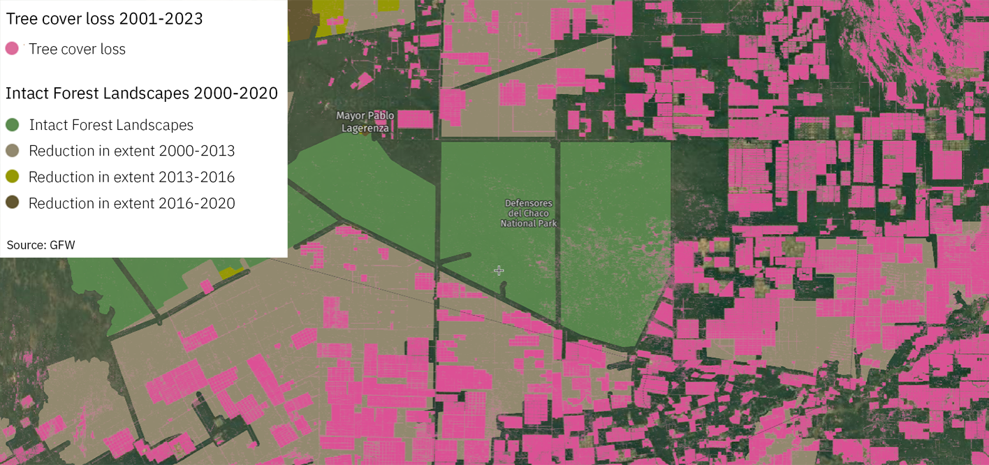
Worldwide, 155 Mha of forest area — roughly equivalent to the size of Mongolia — that was considered intact in 2000 could no longer be considered intact in 2020, corresponding to a reduction of approximately 7.8 Mha of intact forest per year and a total reduction of 12 percent of intact forest area. Russia experienced the largest reduction of intact forest area (41 Mha), primarily due to fire. Romania saw the largest percentage (100 percent) decline, with its last remaining tract of intact forest fragmented by new transportation infrastructure between 2000 and 2013. Paraguay also experienced a notable decline, with an 81 percent decrease in forest area that could be considered intact between 2000 and 2020 due to the clearing of the Chaco for cattle ranching.
More
Reduction of intact forest area by country
More
Tree cover loss caused by cattle ranching in northern Paraguay causes many forest areas to lose their “intact” status
More
How much humid tropical forest has experienced temporary disturbances?
Human activities and natural events can lead to temporary disturbances, which can be considered a form of degradation, and thus can have significant implications for biodiversity, ecosystem services and carbon storage. The European Commission Joint Research Centre‘s Tropical Moist Forests data set maps temporary disturbances — called degradation in the data set — across the humid tropics from 1990-2023, finding that 153.2 Mha — an area roughly equivalent to the size of Peru — or 14 percent of standing forest in this region experienced temporary disturbances during this time period. Approximately 37 percent of these disturbances occurred in Asia and Oceania, 41 percent in the Americas and 22 percent in Africa. The data set classifies disturbances based on their duration as observed through satellite imagery: 70.6 Mha experienced a single “short-duration degradation” event, meaning that disturbances were visible for less than one year, including events such as selective logging, low-intensity fires or natural disturbances such as hurricanes or droughts; 64.6 Mha experienced multiple (two to three) short-duration degradation events throughout the time period; 11.7 Mha experienced “long-duration degradation,” meaning that disturbances were visible for 1-2.5 years, such as more intense fires; 1.3 Mha experienced degradation in mangrove areas and 4.9 Mha experienced recent degradation starting in 2023. An additional 50.8 Mha of temporary disturbances were followed in later years by permanent forest loss, highlighting how these events can lead to long-term impacts.
More
Temporary disturbances in humid tropical forests from 1990-2023
More
Limitations and Future Prospects
Forest degradation is notoriously difficult to define due to varied perceptions of which forest attributes matter most. It represents a reduction in a forest’s ability to perform ecosystem services, such as carbon storage and water regulation, due to natural and anthropogenic changes. There is no simple or widely accepted method for measuring forest degradation or assessing the resulting forest quality. The condition of forests may decline for different reasons, and degradation in one dimension of forest quality (e.g., water regulation) will not necessarily correlate with degradation in another (e.g., biodiversity). Likewise, changing conditions of a forest may result in some dimension declining, while others may improve. A further challenge is that forest degradation is incremental and often involves subtle change that are difficult to measure, especially with medium-resolution satellite imagery from passive optical sensors that is typically used in global forest monitoring systems. Finally, measuring forest degradation requires methods that can distinguish short-term fluctuations due to changing seasons or natural disturbances — such as fires, floods and droughts — from persistent trends that are more likely indicative of long-term degradation.
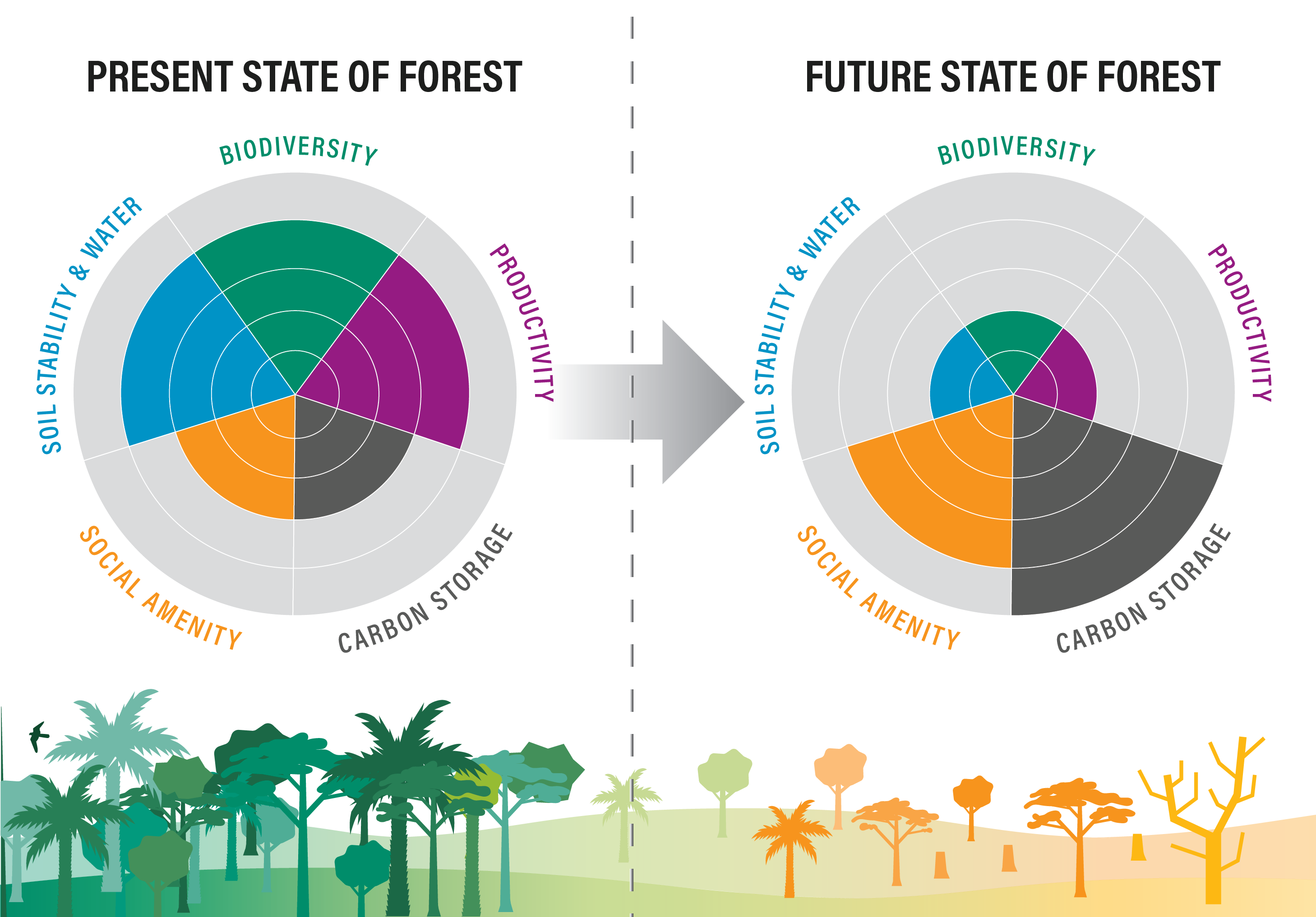
The data sets used in this indicator are only proxies, indicating where degradation may have occurred. They are not direct measures of the extent of degradation that has occurred. As new data sets are developed, a multidimensional framework, such as that shown in the diagram below, could enable degradation in a specific forest to be measured against a suite of values, and targets could be set according to the management priorities for that forest.
More
Diagram illustrating how various dimensions of forest quality can change over time and are dependent on local context. For example, if a well-managed selective logging concession in a secondary forest is abandoned and later experiences illegal encroachment with activities such as mining or hunting, carbon and social amenity might increase, while biodiversity, productivity, and soil stability and water may decrease.
More
{"Glossary":{"51":{"name":"agricultural tree crops","description":"Trees cultivated for their food, cultural, or economic values. These include oil palm, rubber, cocoa, cashew, mango, oranges (citrus), plantain, banana, and coconut.\r\n"},"141":{"name":"agroforestry","description":"A diversified set of agricultural or agropastoral production systems that integrate trees in the agricultural landscape.\r\n"},"101":{"name":"albedo","description":"The ability of surfaces to reflect sunlight.\u0026nbsp;Light-colored surfaces return a large part of the sunrays back to the atmosphere (high albedo). Dark surfaces absorb the rays from the sun (low albedo).\r\n"},"94":{"name":"biodiversity intactness","description":"The proportion and abundance of a location\u0027s original forest community (number of species and individuals) that remain.\u0026nbsp;\r\n"},"95":{"name":"biodiversity significance","description":"The importance of an area for the persistence of forest-dependent species based on range rarity.\r\n"},"142":{"name":"boundary plantings","description":"Trees planted along boundaries or property lines to mark them well.\r\n"},"98":{"name":"carbon dioxide equivalent (CO2e)","description":"Carbon dioxide equivalent (CO2e) is a measure used to aggregate emissions from various greenhouse gases (GHGs) on the basis of their 100-year global warming potentials by equating non-CO2 GHGs to the equivalent amount of CO2.\r\n"},"99":{"name":"CO2e","description":"Carbon dioxide equivalent (CO2e) is a measure used to aggregate emissions from various greenhouse gases (GHGs) on the basis of their 100-year global warming potentials by equating non-CO2 GHGs to the equivalent amount of CO2.\r\n"},"1":{"name":"deforestation","description":"The change from forest to another land cover or land use, such as forest to plantation or forest to urban area.\r\n"},"77":{"name":"deforested","description":"The change from forest to another land cover or land use, such as forest to plantation or forest to urban area.\r\n"},"76":{"name":"degradation","description":"The reduction in a forest\u2019s ability to perform ecosystem services, such as carbon storage and water regulation, due to natural and anthropogenic changes.\r\n"},"75":{"name":"degraded","description":"The reduction in a forest\u2019s ability to perform ecosystem services, such as carbon storage and water regulation, due to natural and anthropogenic changes.\r\n"},"79":{"name":"disturbances","description":"A discrete event that changes the structure of a forest ecosystem.\r\n"},"68":{"name":"disturbed","description":"A discrete event that changes the structure of a forest ecosystem.\r\n"},"65":{"name":"driver of tree cover loss","description":"The direct cause of forest disturbance.\r\n"},"70":{"name":"drivers of loss","description":"The direct cause of forest disturbance.\r\n"},"81":{"name":"drivers of tree cover loss","description":"The direct cause of forest disturbance.\r\n"},"102":{"name":"evapotranspiration","description":"When solar energy hitting a forest converts liquid water into water vapor (carrying energy as latent heat) through evaporation and transpiration.\r\n"},"2":{"name":"forest","description":"Forests include tree cover greater than 30 percent tree canopy density and greater than 5 meters in height as mapped at a 30-meter Landsat pixel scale.\r\n"},"3":{"name":"forest concession","description":"A legal agreement allowing an entity the right to manage a public forest for production purposes.\r\n"},"90":{"name":"forest concessions","description":"A legal agreement allowing an entity the right to manage a public forest for production purposes.\r\n"},"53":{"name":"forest degradation","description":"The reduction in a forest\u2019s ability to perform ecosystem services, such as carbon storage and water regulation, due to natural and anthropogenic changes.\r\n"},"54":{"name":"forest disturbance","description":"A discrete event that changes the structure of a forest ecosystem.\r\n"},"100":{"name":"forest disturbances","description":"A discrete event that changes the structure of a forest ecosystem.\r\n"},"5":{"name":"forest fragmentation","description":"The breaking of large, contiguous forests into smaller pieces, with other land cover types interspersed.\r\n"},"6":{"name":"forest management plan","description":"A plan that documents the stewardship and use of forests and other wooded land to meet environmental, economic, social, and cultural objectives. Such plans are typically implemented by companies in forest concessions.\r\n"},"62":{"name":"forests","description":"Forests include tree cover greater than 30 percent tree canopy density and greater than 5 meters in height as mapped at a 30-meter Landsat pixel scale.\r\n"},"69":{"name":"fragmentation","description":"The breaking of large, contiguous forests into smaller pieces, with other land cover types interspersed.\r\n"},"80":{"name":"fragmented","description":"The breaking of large, contiguous forests into smaller pieces, with other land cover types interspersed.\r\n"},"74":{"name":"gain","description":"The establishment of tree canopy in an area that previously had no tree cover. Tree cover gain may indicate a number of potential activities, including natural forest growth or the crop rotation cycle of tree plantations.\r\n"},"143":{"name":"global land squeeze","description":"Pressure on finite land resources to produce food, feed and fuel for a growing human population while also sustaining biodiversity and providing ecosystem services.\r\n"},"7":{"name":"hectare","description":"One hectare equals 100 square meters, 2.47 acres, or 0.01 square kilometers and is about the size of a rugby field. A football pitch is slightly smaller than a hectare (pitches are between 0.62 and 0.82 hectares).\r\n"},"66":{"name":"hectares","description":"One hectare equals 100 square meters, 2.47 acres, or 0.01 square kilometers and is about the size of a rugby field. A football pitch is slightly smaller than a hectare (pitches are between 0.62 and 0.82 hectares).\r\n"},"67":{"name":"intact","description":"A forest that contains no signs of human activity or habitat fragmentation as determined by remote sensing images and is large enough to maintain all native biological biodiversity.\r\n"},"78":{"name":"intact forest","description":"A forest that contains no signs of human activity or habitat fragmentation as determined by remote sensing images and is large enough to maintain all native biological biodiversity.\r\n"},"8":{"name":"intact forests","description":"A forest that contains no signs of human activity or habitat fragmentation as determined by remote sensing images and is large enough to maintain all native biological biodiversity.\r\n"},"55":{"name":"land and environmental defenders","description":"People who peacefully promote and protect rights related to land and\/or the environment.\r\n"},"9":{"name":"loss driver","description":"The direct cause of forest disturbance.\r\n"},"10":{"name":"low tree canopy density","description":"Less than 30 percent tree canopy density.\r\n"},"84":{"name":"managed forest concession","description":"Areas where governments have given rights to private companies to harvest timber and other wood products from natural forests on public lands.\r\n"},"83":{"name":"managed forest concession maps for nine countries","description":"Cameroon, Canada, Central African Republic, Democratic Republic of the Congo, Equatorial Guinea, Gabon, Indonesia, Liberia, and the Republic of the Congo\r\n"},"104":{"name":"managed natural forests","description":"Naturally regenerated forests with signs of management, including logging, clear cuts, etc.\r\n"},"91":{"name":"megacities","description":"A city with more than 10 million people.\r\n"},"57":{"name":"megacity","description":"A city with more than 10 million people."},"56":{"name":"mosaic restoration","description":"Restoration that integrates trees into mixed-use landscapes, such as agricultural lands and settlements, where trees can support people through improved water quality, increased soil fertility, and other ecosystem services. This type of restoration is more likely in deforested or degraded forest landscapes with moderate population density (10\u2013100 people per square kilometer). "},"86":{"name":"natural","description":"A forest that is grown without human intervention.\r\n"},"12":{"name":"natural forest","description":"A forest that is grown without human intervention.\r\n"},"63":{"name":"natural forests","description":"A forest that is grown without human intervention.\r\n"},"144":{"name":"open canopy systems","description":"Individual tree crowns that do not overlap to form a continuous canopy layer.\r\n"},"82":{"name":"persistent gain","description":"Forests that have experienced one gain event from 2001 to 2016.\r\n"},"13":{"name":"persistent loss and gain","description":"Forests that have experienced one loss or one gain event from 2001 to 2016."},"97":{"name":"plantation","description":"An area in which trees have been planted, generally for commercial purposes.\u0026nbsp;\r\n"},"93":{"name":"plantations","description":"An area in which trees have been planted, generally for commercial purposes.\u0026nbsp;\r\n"},"88":{"name":"planted","description":"A forest composed of trees that have been deliberately planted and\/or seeded by humans.\r\n"},"14":{"name":"planted forest","description":"Stand of planted trees \u2014 other than tree crops \u2014 grown for wood and wood fiber production or for ecosystem protection against wind and\/or soil erosion.\r\n"},"73":{"name":"planted forests","description":"Stand of planted trees \u2014 other than tree crops \u2014 grown for wood and wood fiber production or for ecosystem protection against wind and\/or soil erosion."},"148":{"name":"planted trees","description":"Stand of trees established through planting, including both planted forest and tree crops."},"149":{"name":"Planted trees","description":"Stand of trees established through planting, including both planted forest and tree crops."},"15":{"name":"primary forest","description":"Old-growth forests that are typically high in carbon stock and rich in biodiversity. The GFR uses a humid tropical primary rainforest data set, representing forests in the humid tropics that have not been cleared in recent years.\r\n"},"64":{"name":"primary forests","description":"Old-growth forests that are typically high in carbon stock and rich in biodiversity. The GFR uses a humid tropical primary rainforest data set, representing forests in the humid tropics that have not been cleared in recent years.\r\n"},"58":{"name":"production forest","description":"A forest where the primary management objective is to produce timber, pulp, fuelwood, and\/or nonwood forest products."},"89":{"name":"production forests","description":"A forest where the primary management objective is to produce timber, pulp, fuelwood, and\/or nonwood forest products.\r\n"},"87":{"name":"seminatural","description":"A managed forest modified by humans, which can have a different species composition from surrounding natural forests.\r\n"},"59":{"name":"seminatural forests","description":"A managed forest modified by humans, which can have a different species composition from surrounding natural forests. "},"96":{"name":"shifting agriculture","description":"Temporary loss or permanent deforestation due to small- and medium-scale agriculture.\r\n"},"103":{"name":"surface roughness","description":"Surface roughness of forests creates\u0026nbsp;turbulence that slows near-surface winds and cools the land as it lifts heat from low-albedo leaves and moisture from evapotranspiration high into the atmosphere and slows otherwise-drying winds. \r\n"},"17":{"name":"tree cover","description":"All vegetation greater than five meters in height and may take the form of natural forests or plantations across a range of canopy densities. Unless otherwise specified, the GFR uses greater than 30 percent tree canopy density for calculations.\r\n"},"71":{"name":"tree cover canopy density is low","description":"Less than 30 percent tree canopy density.\r\n"},"60":{"name":"tree cover gain","description":"The establishment of tree canopy in an area that previously had no tree cover. Tree cover gain may indicate a number of potential activities, including natural forest growth or the crop rotation cycle of tree plantations.\u0026nbsp;As such, tree cover gain does not equate to restoration.\r\n"},"18":{"name":"tree cover loss","description":"The removal or mortality of tree cover, which can be due to a variety of factors, including mechanical harvesting, fire, disease, or storm damage. As such, loss does not equate to deforestation.\r\n"},"150":{"name":"tree crops","description":"Stand of perennial trees that produce agricultural products, such as rubber, oil palm, coffee, coconut, cocoa and orchards."},"19":{"name":"tree plantation","description":"An agricultural plantation of fast-growing tree species on short rotations for the production of timber, pulp, or fruit.\r\n"},"72":{"name":"tree plantations","description":"An agricultural plantation of fast-growing tree species on short rotations for the production of timber, pulp, or fruit.\r\n"},"85":{"name":"trees outside forests","description":"Trees found in urban areas, alongside roads, or within agricultural land\u0026nbsp;are often referred to as Trees Outside Forests (TOF).\u202f\r\n"},"151":{"name":"unmanaged","description":"Naturally regenerated forests without any signs of management, including primary forest."},"105":{"name":"unmanaged natural forests","description":"Naturally regenerated forests without any signs of management, including primary forest.\r\n"}}}
 Forest Degradation
