Course 3: Protect and Restore Natural Ecosystems and Limit Agricultural Land-Shifting (Synthesis)
{"Glossary":{"51":{"name":"agricultural tree crops","description":"Trees cultivated for their food, cultural, or economic values. These include oil palm, rubber, cocoa, cashew, mango, oranges (citrus), plantain, banana, and coconut.\r\n"},"141":{"name":"agroforestry","description":"A diversified set of agricultural or agropastoral production systems that integrate trees in the agricultural landscape.\r\n"},"101":{"name":"albedo","description":"The ability of surfaces to reflect sunlight.\u0026nbsp;Light-colored surfaces return a large part of the sunrays back to the atmosphere (high albedo). Dark surfaces absorb the rays from the sun (low albedo).\r\n"},"94":{"name":"biodiversity intactness","description":"The proportion and abundance of a location\u0027s original forest community (number of species and individuals) that remain.\u0026nbsp;\r\n"},"95":{"name":"biodiversity significance","description":"The importance of an area for the persistence of forest-dependent species based on range rarity.\r\n"},"142":{"name":"boundary plantings","description":"Trees planted along boundaries or property lines to mark them well.\r\n"},"98":{"name":"carbon dioxide equivalent (CO2e)","description":"Carbon dioxide equivalent (CO2e) is a measure used to aggregate emissions from various greenhouse gases (GHGs) on the basis of their 100-year global warming potentials by equating non-CO2 GHGs to the equivalent amount of CO2.\r\n"},"99":{"name":"CO2e","description":"Carbon dioxide equivalent (CO2e) is a measure used to aggregate emissions from various greenhouse gases (GHGs) on the basis of their 100-year global warming potentials by equating non-CO2 GHGs to the equivalent amount of CO2.\r\n"},"1":{"name":"deforestation","description":"The change from forest to another land cover or land use, such as forest to plantation or forest to urban area.\r\n"},"77":{"name":"deforested","description":"The change from forest to another land cover or land use, such as forest to plantation or forest to urban area.\r\n"},"76":{"name":"degradation","description":"The reduction in a forest\u2019s ability to perform ecosystem services, such as carbon storage and water regulation, due to natural and anthropogenic changes.\r\n"},"75":{"name":"degraded","description":"The reduction in a forest\u2019s ability to perform ecosystem services, such as carbon storage and water regulation, due to natural and anthropogenic changes.\r\n"},"79":{"name":"disturbances","description":"A discrete event that changes the structure of a forest ecosystem.\r\n"},"68":{"name":"disturbed","description":"A discrete event that changes the structure of a forest ecosystem.\r\n"},"65":{"name":"driver of tree cover loss","description":"The direct cause of forest disturbance.\r\n"},"70":{"name":"drivers of loss","description":"The direct cause of forest disturbance.\r\n"},"81":{"name":"drivers of tree cover loss","description":"The direct cause of forest disturbance.\r\n"},"102":{"name":"evapotranspiration","description":"When solar energy hitting a forest converts liquid water into water vapor (carrying energy as latent heat) through evaporation and transpiration.\r\n"},"2":{"name":"forest","description":"Forests include tree cover greater than 30 percent tree canopy density and greater than 5 meters in height as mapped at a 30-meter Landsat pixel scale.\r\n"},"3":{"name":"forest concession","description":"A legal agreement allowing an entity the right to manage a public forest for production purposes.\r\n"},"90":{"name":"forest concessions","description":"A legal agreement allowing an entity the right to manage a public forest for production purposes.\r\n"},"53":{"name":"forest degradation","description":"The reduction in a forest\u2019s ability to perform ecosystem services, such as carbon storage and water regulation, due to natural and anthropogenic changes.\r\n"},"54":{"name":"forest disturbance","description":"A discrete event that changes the structure of a forest ecosystem.\r\n"},"100":{"name":"forest disturbances","description":"A discrete event that changes the structure of a forest ecosystem.\r\n"},"5":{"name":"forest fragmentation","description":"The breaking of large, contiguous forests into smaller pieces, with other land cover types interspersed.\r\n"},"6":{"name":"forest management plan","description":"A plan that documents the stewardship and use of forests and other wooded land to meet environmental, economic, social, and cultural objectives. Such plans are typically implemented by companies in forest concessions.\r\n"},"62":{"name":"forests","description":"Forests include tree cover greater than 30 percent tree canopy density and greater than 5 meters in height as mapped at a 30-meter Landsat pixel scale.\r\n"},"69":{"name":"fragmentation","description":"The breaking of large, contiguous forests into smaller pieces, with other land cover types interspersed.\r\n"},"80":{"name":"fragmented","description":"The breaking of large, contiguous forests into smaller pieces, with other land cover types interspersed.\r\n"},"74":{"name":"gain","description":"The establishment of tree canopy in an area that previously had no tree cover. Tree cover gain may indicate a number of potential activities, including natural forest growth or the crop rotation cycle of tree plantations.\r\n"},"143":{"name":"global land squeeze","description":"Pressure on finite land resources to produce food, feed and fuel for a growing human population while also sustaining biodiversity and providing ecosystem services.\r\n"},"7":{"name":"hectare","description":"One hectare equals 100 square meters, 2.47 acres, or 0.01 square kilometers and is about the size of a rugby field. A football pitch is slightly smaller than a hectare (pitches are between 0.62 and 0.82 hectares).\r\n"},"66":{"name":"hectares","description":"One hectare equals 100 square meters, 2.47 acres, or 0.01 square kilometers and is about the size of a rugby field. A football pitch is slightly smaller than a hectare (pitches are between 0.62 and 0.82 hectares).\r\n"},"67":{"name":"intact","description":"A forest that contains no signs of human activity or habitat fragmentation as determined by remote sensing images and is large enough to maintain all native biological biodiversity.\r\n"},"78":{"name":"intact forest","description":"A forest that contains no signs of human activity or habitat fragmentation as determined by remote sensing images and is large enough to maintain all native biological biodiversity.\r\n"},"8":{"name":"intact forests","description":"A forest that contains no signs of human activity or habitat fragmentation as determined by remote sensing images and is large enough to maintain all native biological biodiversity.\r\n"},"55":{"name":"land and environmental defenders","description":"People who peacefully promote and protect rights related to land and\/or the environment.\r\n"},"9":{"name":"loss driver","description":"The direct cause of forest disturbance.\r\n"},"10":{"name":"low tree canopy density","description":"Less than 30 percent tree canopy density.\r\n"},"84":{"name":"managed forest concession","description":"Areas where governments have given rights to private companies to harvest timber and other wood products from natural forests on public lands.\r\n"},"83":{"name":"managed forest concession maps for nine countries","description":"Cameroon, Canada, Central African Republic, Democratic Republic of the Congo, Equatorial Guinea, Gabon, Indonesia, Liberia, and the Republic of the Congo\r\n"},"104":{"name":"managed natural forests","description":"Naturally regenerated forests with signs of management, including logging, clear cuts, etc.\r\n"},"91":{"name":"megacities","description":"A city with more than 10 million people.\r\n"},"57":{"name":"megacity","description":"A city with more than 10 million people."},"56":{"name":"mosaic restoration","description":"Restoration that integrates trees into mixed-use landscapes, such as agricultural lands and settlements, where trees can support people through improved water quality, increased soil fertility, and other ecosystem services. This type of restoration is more likely in deforested or degraded forest landscapes with moderate population density (10\u2013100 people per square kilometer). "},"86":{"name":"natural","description":"A forest that is grown without human intervention.\r\n"},"12":{"name":"natural forest","description":"A forest that is grown without human intervention.\r\n"},"63":{"name":"natural forests","description":"A forest that is grown without human intervention.\r\n"},"144":{"name":"open canopy systems","description":"Individual tree crowns that do not overlap to form a continuous canopy layer.\r\n"},"82":{"name":"persistent gain","description":"Forests that have experienced one gain event from 2001 to 2016.\r\n"},"13":{"name":"persistent loss and gain","description":"Forests that have experienced one loss or one gain event from 2001 to 2016."},"97":{"name":"plantation","description":"An area in which trees have been planted, generally for commercial purposes.\u0026nbsp;\r\n"},"93":{"name":"plantations","description":"An area in which trees have been planted, generally for commercial purposes.\u0026nbsp;\r\n"},"88":{"name":"planted","description":"A forest composed of trees that have been deliberately planted and\/or seeded by humans.\r\n"},"14":{"name":"planted forest","description":"Stand of planted trees \u2014 other than tree crops \u2014 grown for wood and wood fiber production or for ecosystem protection against wind and\/or soil erosion.\r\n"},"73":{"name":"planted forests","description":"Stand of planted trees \u2014 other than tree crops \u2014 grown for wood and wood fiber production or for ecosystem protection against wind and\/or soil erosion."},"148":{"name":"planted trees","description":"Stand of trees established through planting, including both planted forest and tree crops."},"149":{"name":"Planted trees","description":"Stand of trees established through planting, including both planted forest and tree crops."},"15":{"name":"primary forest","description":"Old-growth forests that are typically high in carbon stock and rich in biodiversity. The GFR uses a humid tropical primary rainforest data set, representing forests in the humid tropics that have not been cleared in recent years.\r\n"},"64":{"name":"primary forests","description":"Old-growth forests that are typically high in carbon stock and rich in biodiversity. The GFR uses a humid tropical primary rainforest data set, representing forests in the humid tropics that have not been cleared in recent years.\r\n"},"58":{"name":"production forest","description":"A forest where the primary management objective is to produce timber, pulp, fuelwood, and\/or nonwood forest products."},"89":{"name":"production forests","description":"A forest where the primary management objective is to produce timber, pulp, fuelwood, and\/or nonwood forest products.\r\n"},"87":{"name":"seminatural","description":"A managed forest modified by humans, which can have a different species composition from surrounding natural forests.\r\n"},"59":{"name":"seminatural forests","description":"A managed forest modified by humans, which can have a different species composition from surrounding natural forests. "},"96":{"name":"shifting agriculture","description":"Temporary loss or permanent deforestation due to small- and medium-scale agriculture.\r\n"},"103":{"name":"surface roughness","description":"Surface roughness of forests creates\u0026nbsp;turbulence that slows near-surface winds and cools the land as it lifts heat from low-albedo leaves and moisture from evapotranspiration high into the atmosphere and slows otherwise-drying winds. \r\n"},"17":{"name":"tree cover","description":"All vegetation greater than five meters in height and may take the form of natural forests or plantations across a range of canopy densities. Unless otherwise specified, the GFR uses greater than 30 percent tree canopy density for calculations.\r\n"},"71":{"name":"tree cover canopy density is low","description":"Less than 30 percent tree canopy density.\r\n"},"60":{"name":"tree cover gain","description":"The establishment of tree canopy in an area that previously had no tree cover. Tree cover gain may indicate a number of potential activities, including natural forest growth or the crop rotation cycle of tree plantations.\u0026nbsp;As such, tree cover gain does not equate to restoration.\r\n"},"18":{"name":"tree cover loss","description":"The removal or mortality of tree cover, which can be due to a variety of factors, including mechanical harvesting, fire, disease, or storm damage. As such, loss does not equate to deforestation.\r\n"},"150":{"name":"tree crops","description":"Stand of perennial trees that produce agricultural products, such as rubber, oil palm, coffee, coconut, cocoa and orchards."},"19":{"name":"tree plantation","description":"An agricultural plantation of fast-growing tree species on short rotations for the production of timber, pulp, or fruit.\r\n"},"72":{"name":"tree plantations","description":"An agricultural plantation of fast-growing tree species on short rotations for the production of timber, pulp, or fruit.\r\n"},"85":{"name":"trees outside forests","description":"Trees found in urban areas, alongside roads, or within agricultural land\u0026nbsp;are often referred to as Trees Outside Forests (TOF).\u202f\r\n"},"151":{"name":"unmanaged","description":"Naturally regenerated forests without any signs of management, including primary forest."},"105":{"name":"unmanaged natural forests","description":"Naturally regenerated forests without any signs of management, including primary forest.\r\n"}}}
Course 3
Protect and Restore Natural Ecosystems and Limit Agricultural Land-Shifting (Synthesis)
This course focuses on the land-management efforts that must complement food demand-reduction efforts and productivity gains to avoid the harms of agricultural land expansion. One guiding principle is the need to make land-use decisions that enhance efficiency for all purposes—not just agriculture but also carbon storage and other ecosystem services. Another principle is the need to explicitly link efforts to boost agricultural yield gains with protection of natural lands.
The Causes and Consequences of Shifting Agricultural Land
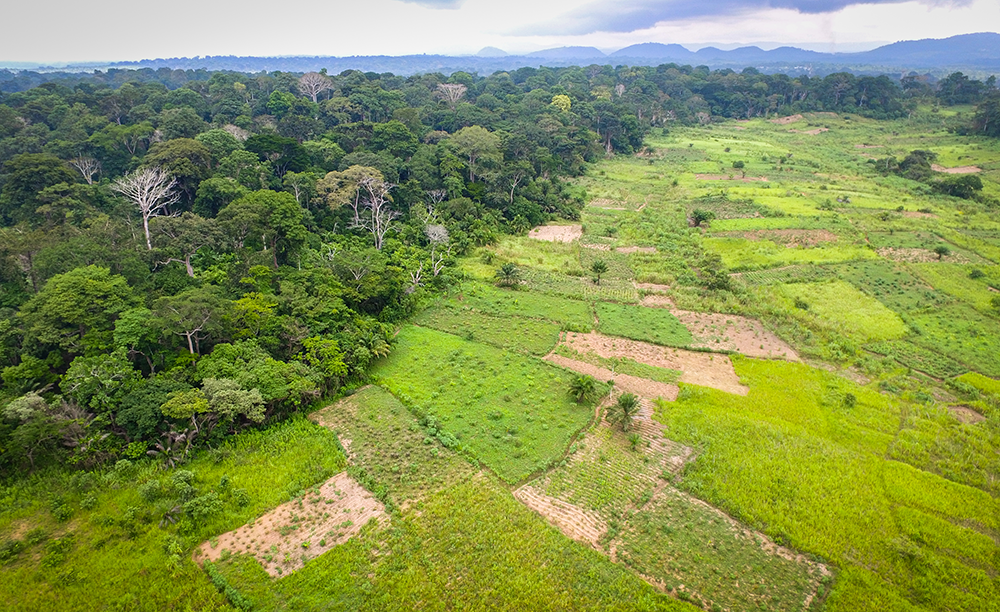
Merely eliminating the need for a net expansion of agricultural land will not avoid all carbon and ecosystem losses because agricultural land is not merely expanding, it is also shifting. At a regional level, agricultural land is shifting from developed to developing countries.53 One reason is that growth in population and food demand is mostly occurring in developing countries. Rising food demand in sub-Saharan Africa, for example, is likely to drive cropland expansion of 100 Mha between 2010 and 2050, even allowing for high estimated yield gains in the region and continued importation of roughly one-fifth of staple foods. Another reason is growing global demand for some highly traded crops that developing countries have learned to grow well, such as soybeans and palm oil.
Agricultural land is also shifting within regions and countries, particularly from less productive and more sloped lands to flatter, more productive, more densely vegetated lands. These shifts result in gross forest losses that are much larger than net losses (Figure 12). Many abandoned agricultural lands do reforest but, unfortunately, the trade-off when native forests are replaced with planting or regrowing forests elsewhere is not environmentally neutral. Conversion of natural ecosystems, which is occurring mostly in the tropics and neotropics, tends to release more carbon per unit of food54 and harm more biodiversity than reforestation of abandoned land offsets elsewhere. The losses of carbon during land conversion also occur quickly, whereas rebuilding carbon in vegetation and soils occurs gradually over longer time periods, exacerbating climate change in the interim.55 The common tendency of countries to replant abandoned land as forest plantations also reduces carbon and biodiversity benefits.
A sustainable food future therefore requires efforts to reduce agricultural land-shifting, minimize the environmental consequences of inevitable expansion in some countries, and more actively reforest abandoned agricultural land. Under the Bonn Challenge—a global effort to bring 350 Mha into restoration by 2030—47 national and subnational actors have now committed to restore over 160 Mha.56
Figure 12 |
Gross forest losses are far greater than net forest losses because agricultural lands are shifting
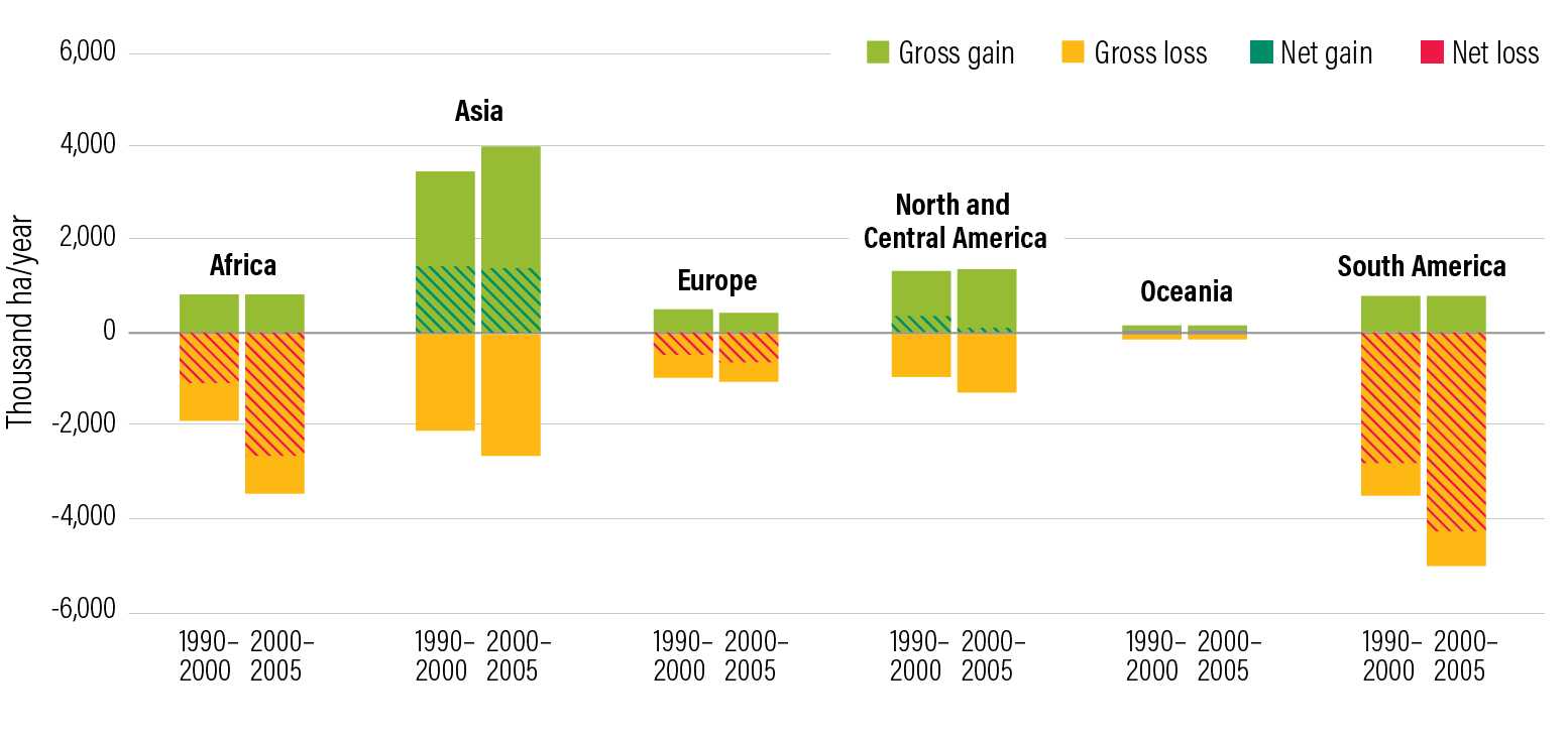
Source
FAO (2012a).
-
In some countries, preventing all agricultural land expansion is not feasible. For example, rising food demand in Africa will realistically require some land expansion, as will global demand for vegetable oil in Southeast Asia. In countries where expansion or shifts of agricultural land are inevitable, countries need to identify and facilitate expansion only where it would cause less environmental harm.
The goal is to find lands with relatively low environmental (and other) opportunity costs but with good productive potential. These opportunities involve trade-offs (Figure 13). Evaluation of land conversion requires assessing not only the loss of existing carbon but also the forgone carbon sequestration on lands that would otherwise regenerate, for example, on cut-over areas. It should also require analysis of the carbon and biodiversity losses per ton of crop (not per hectare) to minimize total environmental costs while meeting food needs.
This menu item requires above all a commitment by national governments, but it also requires tools that international aid agencies should help fund and that could also help link agricultural improvement and natural landscape protection more generally:
- Tools and models must estimate likely yields and effects on biodiversity and carbon of different development patterns, incorporate information on various obstacles, and allow a wide range of stakeholders to explore acceptable alternatives. A tool developed for Zambia, for example, showed how balancing production and environmental goals could come close to maximizing yield potential while holding down transportation costs, carbon losses, and adverse effects on biodiversity.61
- Integrating such tools with analyses of agricultural potential and current farming systems on existing agricultural land could help target use of agricultural improvement funds. Tools that are useful at the farm level and then aggregate to the regional and national level have the greatest potential because their use should improve the quality of analysis over time.
- Governments will need to use such assessment tools to guide land-use regulations, plan road routes, and manage public lands.
Figure 13 |
Screening out lands that do not meet environmental, economic, and legal criteria reduces the area of land suitable for oil palm expansion in Kalimantan, Indonesia
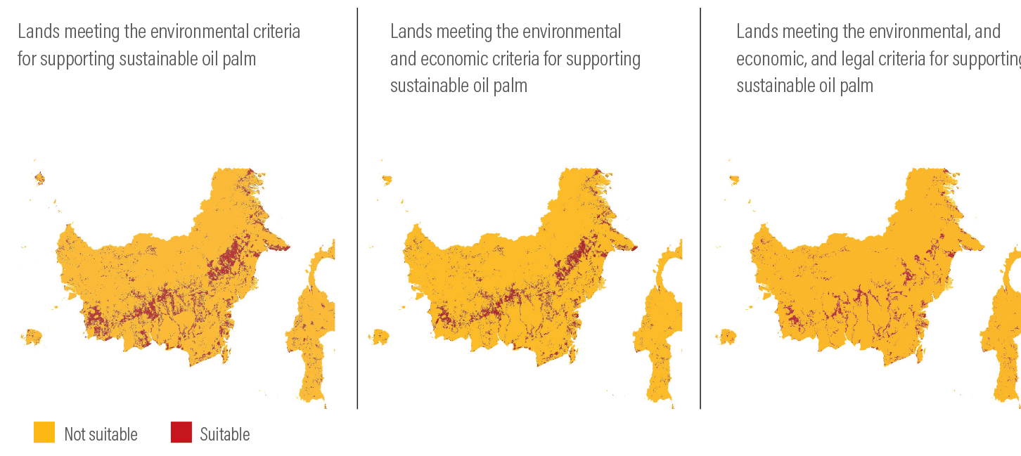
Source
Gingold et al. (2012)
-
The highest priority for immediate restoration should be the world’s 26 Mha of drained peatlands. This small area is responsible for roughly 2 percent of annual human-caused GHG emissions, according to our estimates. The best evidence indicates that roughly half of these peatlands have little or no agricultural use or are used only for grazing.
Peatlands are wetlands that built up massive carbon-rich soils over hundreds or thousands of years.65 Their conversion for agriculture and plantation forestry typically requires drainage, which causes the soils to decompose and sometimes burn, releasing large quantities of carbon into the atmosphere (Figure 14). Rewetting peatlands by blocking drainage ditches can typically eliminate emissions.
Peatlands appear to be far more extensive than previously thought, suggesting high risk of further losses. Researchers have recently discovered the world’s largest tropical peatland in the heart of the Congo rainforest in central Africa.66 It stores an estimated 30 gigatons of carbon, equivalent to roughly 20 years of U.S. fossil fuel emissions. Other large peatlands probably exist in Latin America.
Modest efforts at restoration have occurred in Russia.67 The president of Indonesia has announced a broad restoration goal, and the country reported 200,000 hectares of peatland restoration between 2017 and 2018.68 Yet the global effort to restore peatlands is minimal compared to the need. Eliminating half of peatland emissions would close the global GHG emissions gap by 5 percent, while eliminating 75 percent would close the GHG mitigation gap by 7 percent. A series of actions is required:
- Restoration efforts require more funding both to perform the physical restoration and to compensate farmers and communities who must forgo other uses, even if relatively modest. Ideally, assistance would be used to boost productivity on farms outside peatlands.
- Peatland conservation and restoration require better mapping, especially because peatlands cannot be identified from satellite imagery. Mapping and data collection should be a priority for national governments, international agencies, and even private parties.
- Strong laws must protect peatlands to prevent their conversion to agriculture.
Figure 14 |
Greenhouse gas emissions from drained peatlands are ongoing in Indonesia and Malaysia
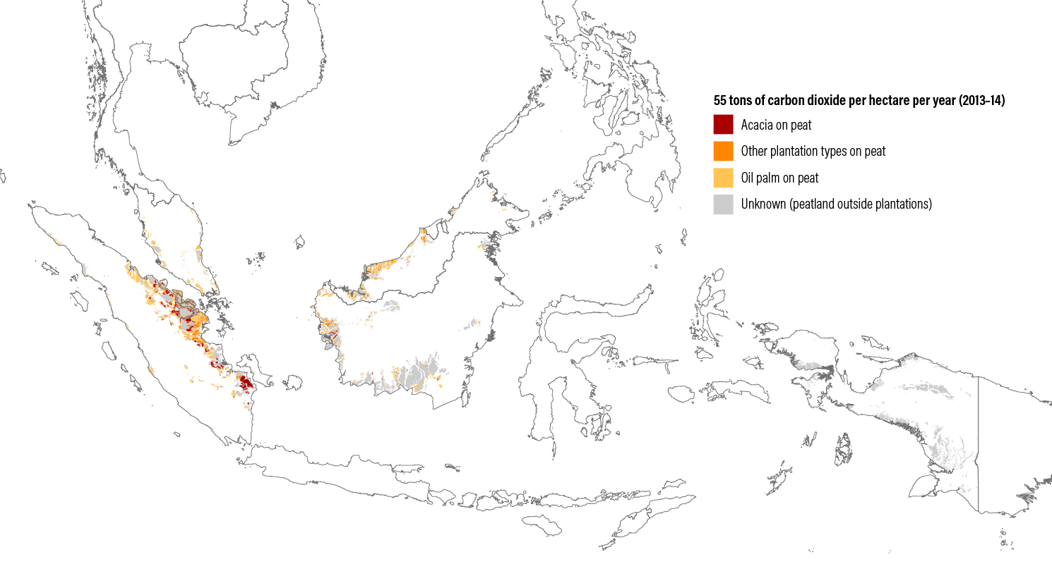
Source
WRI (2017).
Endnotes
- 53FAO (2017a).
- 54West et al. (2010).
- 55Hirsch et al. (2004).
- 56See http://www.bonnchallenge.org/commitments. A variety of scenarios exist to achieve global warming of 1.5°C only but all are uncertain and almost all require substantial “negative emissions,” i.e., withdrawals of carbon from the air. We estimate that 585 Mha of reforestation on liberated agricultural land would be needed to fully offset 4 Gt of agricultural emissions. These offsets would persist for 40 years after which other reductions or offsets would be required. This could only be achieved through actions across many menu items in Course 1 (reduce demand), Course 2 (increase productivity), and Course 3 (protect and restore natural ecosystems and limit agricultural land-shifting). The 350 Mha restoration target in the Bonn Challenge includes reforestation, agroforestry, soil enhancement, and other productive forms of restoration. Thus the Bonn Challenge could contribute to the needed 585 Mha.
- 57Laurance et al. (2014).
- 58Wormington (2016).
- 59Jackson (2015); Nepstad et al. (2014); Assunção et al. (2012); Gibbs et al. (2016).
- 60Boyd et al. (2018).
- 61Estes et al. (2016).
- 62In this report, we use the term “restoration” in a relatively narrow sense, meaning to return land to a natural or semi-natural state of vegetation. Other than in the case of peatlands, we usually mean forest restoration. We recognize that the term can be used more broadly, for example, to include agroforestry as a means to restore land to productive use, or more broadly still, to include any measures that restore ecological health to a tract of land, whether or not trees are involved. See, for example, Bessau et al. (eds) (2018); Hanson et al. (2015).
- 63See, for example, Stern (2006); Nabuurs et al. (2007); Sathaye et al. (2011); and Sathaye et al. (2005).
- 64Siddique et al. (2008).
- 65Kolka et al. (2016).
- 66Dargie et al. (2017).
- 67Wetlands International (2017).
- 68Gewin (2018).